
A team of seismologists and geologists have discovered a continent that was hidden for around 375 years. The small team has created a newly refined map of Zealandia or Te Riu-a-Maui, which is considered as the ‘eighth continent of the world’ that is beneath the Pacific Ocean.
The updated map has shown the location of the magmatic arc axis that forms the Zealandia continent as well as a number of important geological features. The researchers found it using the data obtained from dredged rock samples recovered from the ocean floor.
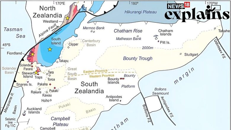
All about Zealandia
Zealandia is a long, narrow landmass that is mostly submerged in the South Pacific Ocean. Measuring 4.9 million square kilometres in size, it is more than six times the size of Madagascar and roughly half of Australia.
It extends from south of New Zealand northward to New Caledonia and west to the Kenn Plateau off Australia’s east.
Apart from New Zealand, the other areas and islands encompassed by the continent include New Caledonia and other Australian territories belonging to the Lord How Island.
The first evidence of its presence was in 1642 when Abel Tasman, a Dutch Sailor, went on a mission to discover a huge continent situated in the Southern Hemisphere.
Then it was first discovered by a group of geologists in 2017 and it formerly belonged to the ancient supercontinent of Gondwana, which was formed about 550 million years ago.
According to the BBC, the newest continent breaks the record for being the smallest, thinnest and youngest in the world.
Why it Took So Long to Discover?
As a large part of the continent was submerged beneath the ocean, Zealandia was not nearly as well studied as the conventional continents, resulting in inconsistencies in its form and structure.
Currently, 94% of the continent is underwater, with just a handful of islands, like New Zealand, thrusting out from its oceanic depths.
Zealandia broke off from Antarctica about 100 million years ago and then from Australia about 80 million years ago.
What Does the New Study Say?
Earlier researches suggested that 83 million years ago, the supercontinent Gondwana was pulled apart by geological forces resulting in the creation of continents- Asia, Africa, Europe, North and South America, Australia and Antarctica. It also led to the creation of Zealandia, which is mostly submerged.
In a new study published in the journal Tectonics, a detailed map of Zealandia was released on Tuesday. The research team also studied the collections of rocks and sediment samples brought from the ocean bed.
“We believe Zealandia is the first of Earth’s continents to have its basement, sedimentary basins, and volcanic rocks fully mapped out to the continent-ocean boundary,” the team of geologists and seismologists said in their paper.
Zealandia is larger than any feature termed microcontinents and if classified as microcontinent, it would be the world’s largest microcontinent in the world, even bigger than the Indian subcontinent.


Comments
0 comment