
Three back-to-back depressions formed in the Bay of Bengal in August powered up the monsoon’s latest vigorous spell over central India, triggering the worst floods of the season in Madhya Pradesh and Odisha.
It was perhaps the second time in nearly 20 years that the Bay of Bengal consecutively churned out three intense low-pressure systems in August, two of which intensified into depressions, and one into a deep depression. As per the India Meteorological Department (IMD) data, the last it happened was in 2006, when four monsoon depressions had formed in August.
“Normally 1-2 depressions are seen in August, but over the last two decades, we have seen their number go down. However, this year, we had three of them, which is significantly above normal. The number of monsoon depressions play an important role in bringing heavy rains to the core monsoon region covering central India and adjoining states,” says Vineet Kumar, postdoctoral researcher at Typhoon Research Centre, Jeju National University, South Korea.
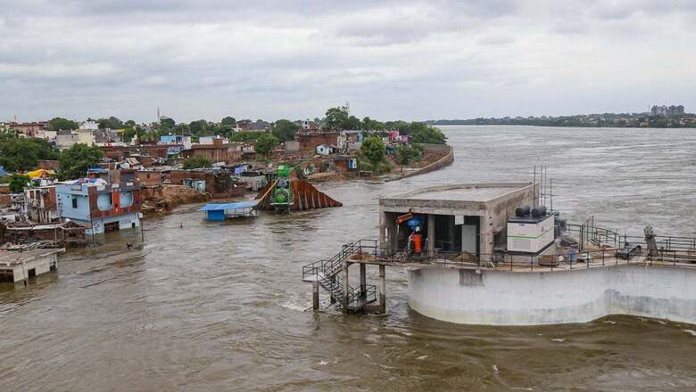
Since the monsoon trough too has been south of its normal position for the most part of the season, all systems travelled westwards from the Bay of Bengal, crossing Odisha, Chhattisgarh towards Madhya Pradesh. The vigorous spell brought upon by the intense monsoon disturbance caused riverine floods across the region, severely impacting the lives of people.
Both Odisha and Madhya Pradesh witnessed the worst floods in the season so far, with Bhopal witnessing severe urban flooding for days altogether.
‘GOOD SIGN FOR MONSOON’
IMD director general (DG) of meteorology M Mohapatra termed the series of low-pressure systems as a good sign for the monsoon, highlighting that these depressions are responsible for the majority of rain that falls during the four-month season starting June 1.
“We normally get up to 13 low-pressure systems during the monsoon season, out of which 5-6 intensify into depressions. So far in this season, we have got nine low-pressure systems, including four depressions. So it is going good so far,” Mohapatra told News18, adding that the year-to-year variations in the numbers of these rain-bearing systems can be quite large.
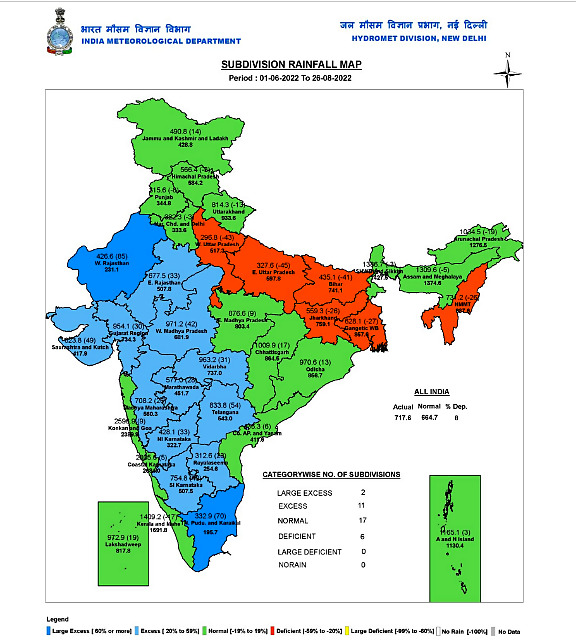
As of August 26, central India has received excess rains to the tune of 23 per cent, compared to 8 per cent of excess rains recorded by the country as a whole. Out of the total 36 subdivisions, as many as 13 have received excess rains, including Rajasthan, Gujarat, as well as Madhya Pradesh.
“Since the monsoon trough has also been south of its normal position for the most part of the season, starting June, the systems have brought above-normal rains to parts of central India, and south peninsula,” said Mohapatra, adding that the number of low-pressure-system days is equally significant. “Usually, we get 57 days of low-pressure systems during monsoon season. This year, we have got 44 days so far.”
According to the top IMD scientist, favourable monsoon conditions have also persisted on account of the La Nina year – a time when cooler surface temperatures are recorded over the equatorial Pacific Ocean. This time, La Nina has persisted for the second consecutive year, after starting in late 2020.
MONSOON DEPRESSION IN BAY OF BENGAL
The first low-pressure area of the month formed over northwest Bay of Bengal on the evening of August 6, which quickly intensified into a depression, and moved towards Madhya Pradesh after crossing Odisha and Chhattisgarh during August 6-11.
Soon thereafter, north Bay of Bengal churned out another low-pressure system on the morning of August 13. This too concentrated into a depression, and moved westwards to Madhya Pradesh after crossing Odisha and Chhattisgarh, and weakened by August 19. The spell of extremely heavy rainfall that followed triggered floods across the region, severely impacting lakhs of people.
Just as the second system was beginning to dissipate, another low-pressure area began brewing over northeast Bay of Bengal on the morning of August 18. It further intensified into a depression, and then into a deep depression as it crossed the coast of West Bengal and Odisha between Balasore and Sagar Islands on August 19. The system too moved across south Jharkhand, north Odisha, and Chhattisgarh before weakening over Madhya Pradesh around August 24. As many as nine subdivisions stretching from Gujarat to Odisha witnessed excess rains due to the week.
Read all the Latest News India and Breaking News here


Comments
0 comment