
In his slim but stately work, Military History of India, Acharya Jadunath Sarkar has commandeered a lasting maxim as far as the military geography of Bharatavarsha is concerned, “Geography has laid down some inexorable laws for the time and manner of conducting military operations in our country.”
Because the maxim is so straightforward and commonsensical, its centrality in deciding the fortunes of Bharatavarsha at critical junctures in our history has been overlooked for the most part. Geography is also war because terrain dictates both strategy and tactics. Intertwined with terrain is climate. Combined, they author and alter history, and nowhere is this more pronounced than in India.
And so, we humbly echo the profound question the Acharya asked himself more than sixty years ago: What is the practical use of the study of the history of military geography to a soldier of today? Is it an unprofitable act of pedantry? And he answers:
No; for if it were so, an intensely practical nation like the English would not have found chairs of military history nor made the military historian a necessary member of a Staff College. The Navy is the senior service in Great Britain, and the importance of military history in its proper functioning is clearly set forth in discussing the life of Sir Herbert Richmond, an experienced admiral and erudite scholar, who may well be called “the Mahan of England.” … History [is] not an end in itself, but as a means of learning something about strategy… Seeing clearly the need to evolve a doctrine of war if the Navy’s effort was not to be wasted when the test came, Richmond was an enthusiastic advocate of the creation of a Naval Staff. (This was done by Mr. Churchill in 1912 and Richmond was appointed to it as Assistant Director of Operations next year. The World War came on 4th August, 1914).
Indeed, Jadunath Sarkar had accurately grasped the pulse of the matter. Sometime in the mid-19th century, Lord Canning proudly boasted that India would firmly remain under England’s stranglehold as long as “our Naval superiority in both Europe and the Indian Seas remained intact.” In fact, there is a crying to study the manner in which the centuries-old Indian naval prowess was criminally squandered away by the Mughals to the great delight of European powers. The indomitable naval Kshatra — warrior-power — built up, buttressed, and sustained by the Gupta and the Chola Empires had sunk into the decadence unleashed by Muslim rule. Thus, even as early as Jahangir’s rule, substantial maritime territories in and around the Bengal region were usurped by the Dutch, Portuguese and the British.
But to summarise a long story, the patriot and nationalist in Jadunath Sarkar offers a precise but humble explanation for the aforementioned study: “This is a civilian’s sufficient apologia for venturing into this field. There is a practical necessity why the wars of India in the past ages should be studied by the soldiers and sailors who are to defend the free India today.”
It must be remembered that Sarkar wrote this treatise about fifteen years after India attained political independence and was dangerously perched on the edge of a skirmish with China.
The Military Geography of Bharatavarsha
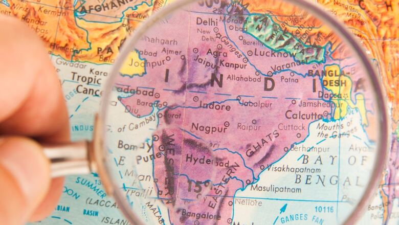
To the inherited Hindu civilisational consciousness, the sacred geography of Bharatavarsha is broadly divided into two parts: Uttarapatha and Dakshinapatha. This geography was — and to a large extent, is still — unified by a shared spiritual culture and life-ideals where political boundaries were secondary at best.
In general, Uttarapatha signifies the entire region north of the Vindhya Range, which included the whole of Pakistan and Afghanistan. Dakshinapatha was the whole region lying south of the Vindhyas. The topographical layout of Uttarapatha and Dakshinapatha are distinguished more by dissimilarity than resemblance.
Uttarapatha
Three features in the geography of Uttarapatha stand out in a pronounced fashion.
The first is the non-contiguous, federated network of awesome snow-clad mountain ranges crowned by the familiar natural fortress of the Himalayan Range, the guardian of northern India since the dawn of its civilisation. The Sulaiman Range closes the Himalayan bracket on the northwestern frontier sloping down to the mouth of the Sindhu River, which empties out into the Arabian Sea.
Running roughly parallel to this range and situated well within mainland India is the dwarfish Aravali Range that overlooks Delhi at its northern end. A free fall from the Aravali Range lands the fortunate soul atop one of the peaks of the imposing Vindhyan Range, the scarped blanket that covers Central India from west to east and divides the Indian peninsula. Vindhya. The natural separator of Bharatavarsha into Uttarapatha and Dakshinapatha. Its southwestern tip, separated by the fertile and gorgeous Narmada Valley, is where the Satpura Range begins and ascends and expands eastwards into an enchanting lushness, until it is rudely cut off at the Baghelkhand Plateau.
The second feature is the collection of hostile playgrounds of nature strewn with deserts, plateaus and interminable stretches of hard, bare rocks and scorching treeless terrains, all of which fall under the suzerainty of these mountain ranges. The Marusthali or the Thar Desert directly parallel to the Aravali Range, and the barren Rann of Kutch to its southwest have sustained their fame of being inhospitable. The Madhya Bharat Pathar (Plateau) situated at the western opposite of the Vindhya Range is a rugged terrain dotted by boulders and scarps and threatening ravines.
The third and the most important feature in the geography of Uttarapatha is where the cradle of the Sanatana Civilisation birthed itself, to borrow a philosophical maxim from Vedanta. Our culture and civilisation began as the refined fruits of eons of spiritual contemplation carried on in the quiet and undisturbed caves and crevices of the Himalayan Range.
From a contemporary perspective, this is the vast and magnificent geographical umbrella that shelters and nurtures a 3300-kilometre expanse from Calcutta in the East to Karachi in the West. The journey which begins at Calcutta first slopes upwards, reaches Patna, moves west, touches Varanasi and then Prayaga, and travels further northwest passing through Agra and then hits Delhi and from there, climbs upwards to the northwest and culminates at Lahore. From Lahore, it slopes downwards to reach Multan before ending its journey in Karachi. Jadunath Sarkar describes this entire terrain in his patented majesty:
From Calcutta to Lahore the distance is 1,300 miles and yet the difference in height above sea-level between these two cities is only a thousand feet, or in other words the ground rises only nine inches in one mile of road… This would not be surprising in the Bengal Delta, but a thousand miles upcountry from Calcutta, the ground formation is the same in the Delhi district. The river Jamuna enters the district at a height of some 710 feet (at the north end) and leaves it at about 630 feet above sea level, with a course within the Delhi limits of rather over 90 miles and the average fall of between ten and eleven inches to the mile.
This is the Great Indian Fertile Plain, home to the maximum number of sites venerated by the Hindu civilisational memory. It includes the hallowed Aryavarta, it was home to the largely forgotten but glorious Sindhu-Sauvira Desha, it is the Ganga-Kshetra (generally but incorrectly known as the Indo-Gangetic Plain) and is the pocket of the celebrated Pancha-Nada Kshetra (undivided Punjab). To an appreciable extent, the entire region retains its preeminence as one of the most ancient civilisational locales of human history.
Indeed, the near-precise recognition of the boundaries of Aryavarta is an eternal testimony to the prestige and farsighted genius of our ancient seers and rishis who recognised this geography and bequeathed its knowledge to hundreds of generations in an era characterised by an absence of modern technology.
To be continued
The author is the founder and chief editor, The Dharma Dispatch. Views expressed in the above piece are personal and solely that of the author. They do not necessarily reflect News18’s views.


Comments
0 comment