
London: Two years after former president APJ Abdul Kalam warned of the security risks posed by Google Earth, reports emerged on Friday of Palestinian militants in the Gaza Strip using the controversial internet site to launch rocket attacks on Israel.
A failed attack on oil facilities in Yemen in September last year was also reportedly planned with the use of Google Earth, which provides detailed satellite maps of the world, the Daily Telegraph reported, without quoting sources.
The newspaper revealed in January that Iraqi insurgents were using Google Earth to attack British bases in Basra, prompting the company to replace images of military positions in the southern Iraqi province with others taken before the war.
Kalam warned of the dangers from Google Earth as early as 2005 when he said its high-resolution images could further compromise the security of some developing countries that were already a target of terrorism.
Google Earth and the Indian Government were later reported to have struck an agreement to show "fuzzy, low resolution pictures and distorted building plans" of installations that the government considered sensitive.
However, Google Earth in partnership with Digital Globe, the world's most advanced commercial imaging satellite, has also responded quickly to provide high resolution photographs during unfolding crises such as the fires now raging in California.
And images provided by it are also being used by experts to analyse and gather startling information.
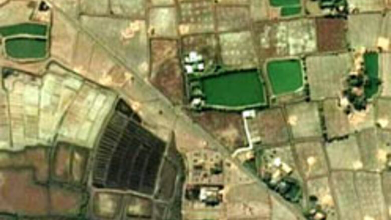
Experts at the Washington-based Institute for Science and International Security (ISIS), an independent body, said on Wednesday that comparisons of Google Earth images of an area in northern Syria before and after an Israeli air attack September 6 show that it may have housed a small nuclear reactor under construction.
Images pre-dating the Israeli attack, about which very little is known, showed a large industrial building and a pumping station near the Euphrates river that the ISIS said bore a resemblance to the Yongbyon nuclear facility in North Korea.
But images taken on October 24 — more than six weeks after the attack — appear to show that the building has been completely removed and the ground scraped clean, the experts said.
The reactor was believed to be of a design thought capable of making about one nuclear weapon's worth of plutonium each year.


Comments
0 comment