
Weather Updates: Chhattisgarh, Jharkhand and Telangana are likely to see thunderstorm accompanied with lightning at isolated places today
Weather Updates: As the monsoon is yet to recede fully, parts of Maharashtra, Karnataka, Tamil Nadu, Puducherry, and Goa and Kerala are likely to witness heavy to very heavy rainfall in the next few days.
The Indian Meteorological Department is predicted heavy to very heavy rainfall at isolated places very likely over Karnataka, Tamil Nadu, Puducherry, Andaman & Nicobar Islands, Maharashtra, Goa, and Kerala on October 16.
The weather forecaster also said that besides these states, Chhattisgarh, Jharkhand and Telangana are likely to see thunderstorm accompanied with lightning at isolated places today.
Here are latest updates on the monsoon activity in the country:
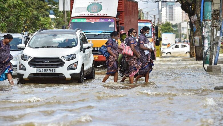
- Following heavy rain in Karnataka’s Mandya, water of overflowing Budanur lake has entered residential area and flooded Bengaluru-Mysuru road.
- Karnataka Minister and Mandya district in-charge minister, K Gopalaiah has visited the rain-affected area in Budanur, Beedi Colony, Vivekananda layout, and Kereyangal.
- Bengaluru city received showers on Saturday. With this, the city has received 170.6 centimetres of rainfall this year, the highest since records began, Deccan Herald reported.
- Madhya Pradesh Agriculture Minister Narendra Singh Tomar said unseasonal rains have damaged crops and the government is waiting for inputs from states to assess the extent of damage.
- The Southwest Monsoon has withdrawn from Bihar, Sikkim, Meghalaya, Madhya Pradesh, some parts of Assam, Tripura and West Bengal, Chhattisgarh and Maharashtra.
- IMD said conditions are very likely to become favourable for further withdrawal of Southwest Monsoon from some more parts of Chhattisgarh, Maharashtra and Jharkhand, Odisha and entire West Bengal during next two days.
- A cyclonic circulation lies over westcentral and adjacent southwest Bay of Bengal in lower tropospheric levels. It is likely to move westwards across south peninsular India during next 2-3 days.
- A cyclonic circulation is likely to form over north Andaman Sea & neighbourhood around October 18, 2022. It would move west northwestwards towards westcentral and adjoining southwest Bay of Bengal becoming low pressure area around October 20, 2022.
- A fresh Western Disturbance is likely to affect Western Himalayan Region from the night of 18th October 2022.
- Dry weather is very likely to prevail over most parts of Northwest and Central India, IMD said in its bulletin today.
Read all the Latest News India and Breaking News here


Comments
0 comment