
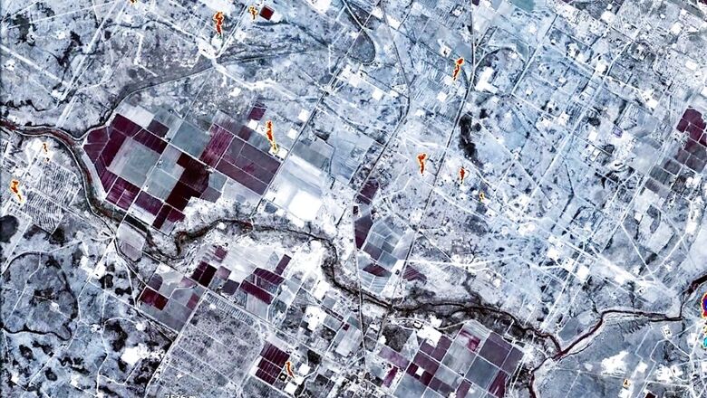
NASA’s realm of coolness extends much beyond space, and in fact, closer to home too. The space agency will now have tools to battle air pollution. In fact, NASA will be able to spot pollution increase, how habitual super-emitters are behaving and will be able to identify exactly what polluting gases are being expelled into the atmosphere. NASA will be working with a nonprofit organization called Carbon Mapper and will have a new Carbon Mapper satellite. This satellite will be first in the Carbon Mapper series and is expected to be launched sometime in 2023. It will have a state-of-the-art imaging spectrometer, which will be able to break down images into hundreds of different colours, to identify the unique structures of molecules of pollutants in the air. These will be used to, as NASA’s Jet Propulsion Laboratory says, measure methane and carbon dioxide point-sources from space.
This comes at a time when global pollution levels are steadily increasing every year. All the data that the Carbon Mapper satellite collects will be made public as well, and will have emissions data of countries, industries and companies as well. “JPL is excited to be pioneering this research effort, which will provide critical information about greenhouse gases and the future of Earth’s climate,” says James Graf, director for the Earth Science and Technology Directorate at JPL. The Carbon Mapper’s imaging spectrometer that will capture and help identify polluting sources on earth, will have a pixel size of about 30 meters (98 feet) square. Other imaging spectrometers currently in orbit have larger pixel sizes, making it hard to pinpoint the locations of sources that may not be visible on the ground, such as cracks in natural gas pipelines. “With such high-resolution images, there is no question where greenhouse gas plumes originate. This technology enables researchers to identify, study, and quantify the strong gas emission sources,” says JPL scientist Charles Miller. The other Carbon Mapper partners are State of California, Planet, the University of Arizona, Arizona State University, High Tide Foundation, and RMI.
Read all the Latest News, Breaking News and Coronavirus News here. Follow us on Facebook, Twitter and Telegram.


Comments
0 comment